The Manitoba Wildfire Service advises that a complete fire ban for the entire burn permit area went into effect Thursday, May 22 at 8am. These restrictions are in place due to wildfire danger levels and ongoing human caused wildfires across the province.
The wildfire danger is currently moderate throughout the province, however the southeast corner and northwest remain dry. Fire and travel restrictions remain at Level 3 in the southeastern regions, including areas 1, 2 and 3 while Area 5 remains at Level 2, which means that motorized backcountry travel is prohibited. For area 8, fire and travel restrictions are at Level 1 and as mentioned, the remaining areas are now under total burn restriction, which means no burning or campfires, even in approved pits. Refer to the areas and further details of the fire and travel restriction map found at gov.mb.ca.
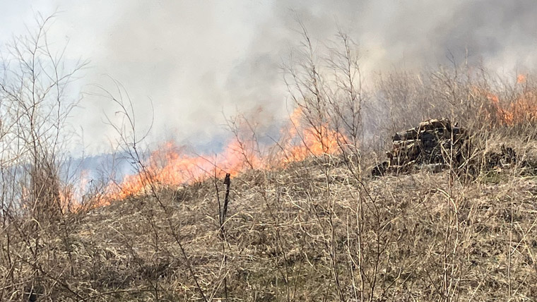
The Manitoba Wildfire Service continues to respond to 12 active wildfires across the province, total of 85 wildfires to date, and continues to respond to the following fires of note:
East Region:
- Fire EA057, located near Carrick, is approximately 9,000 hectares (ha). The Rural Municipality (RM) of Piney has lifted the evacuation order for Woodridge, Badger, St Labre, Carrick and Florze and evacuees have returned home.
- Fire EA061, located one kilometre (km) from Bird River, is approximately 101,000 ha. Mandatory evacuations continue to Pointe du Bois, Nopiming Provincial Park and the RM of Alexander. The Tanco Mine also remains evacuated. An evacuation order remains in place for Wallace Lake Cottage Association.
- Fire EA062, located six km from Lac du Bonnet is approximately 4,000 ha. The RM of Lac du Bonnet and the RM of Alexander have lifted some evacuation orders for evacuees along Provincial Road (PR) 313 up to the intersection of PR 315. Local bylaw enforcement officers, in coordination with the RCMP, continue to maintain 24/7 roadblocks at the intersection of PR 313 and PR 315.
- Fire EA063, located on the Ontario border near Ingolf, is approximately 1,650 ha on the Manitoba side of the border. Progress has been made, allowing select areas in Whiteshell Park that are a safe distance from the wildfire to reopen. This fire originated in Ontario and is also numbered as KEN#020.
- Fire WE004, located from Opaskwayak Cree Nation/The Pas to the north side of Root Lake, is approximately 42,500 ha.
- Fire WE015, located eight km from Carberry Portage in the RM of Kelsey, is approximately 40 ha.
- Fire NO002, located six km from the Town of Lynn Lake, is approximately 1,200 ha.
Many municipalities have proactively implemented burning restrictions this spring, so check with the local municipal office or view the interactive burning restrictions map at manitoba.ca for more information. No burning permits will be issued for areas within or bordering any municipality where burning restrictions are already in place.
Evacuees who need help connecting with their local authorities can contact Manitoba 211 for assistance by calling 211 from anywhere in Manitoba. For more information, visit mb.211.ca.
For further information on the Manitoba Wildfire Service, situation updates, restrictions and other important wildfire links, visit gov.mb.ca. To report a wildfire, call 911 or the TIP line toll-free at 1-800-782-0076.