The Manitoba Wildfire Service (MWS) reports there are large areas of very high-to-extreme fire danger and the areas of fire danger are expanding in the province.
The MWS reminds all Manitobans human activity continues to significantly contribute to Manitoba’s current wildfire situation and to continue to adhere to the fire and travel restrictions for their area. Restrictions in areas 1, 2 and 3 continue at Level 3, Area 5 at Level 2 and Area 8 at Level 1 while remaining areas continue under a total burn restriction, which means no burning or campfires even in approved pits. Refer to the areas and further details of the fire and travel restriction map found at gov.mb.ca.
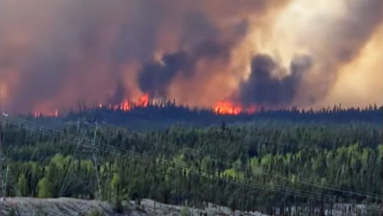
The Manitoba Wildfire Service (MWS) continues to respond to 22 active wildfires across the province, a total of 102 wildfires to date, well above the average for this date of 78 total fires. Fires of note include:
East region:
- Fire EA061, located one kilometre (km) from Bird River, is approximately 124,238 ha and remains out of control. Provincial Road (PR) 315 is closed and blocked at Poplar Bay Road in the Bird River area, with no travel beyond that to Bird River and onwards up to PR 314 and Bissett.
- Fire EA062, located six km from Lac du Bonnet at approximately 4,008 ha is under control.
- Fire EA063, located on the Ontario border near Ingolf, is out of control at approximately 3,771 ha on the Manitoba side of the border and approximately 31,276 ha in total size. This fire originated in Ontario and is also numbered as KEN#020.
West region:
- Fire WE015, located eight km from Cranberry Portage in the Rural Municipality of Kelsey, is being held at approximately 40 ha.
- Fire WE017, located 14 km from Sherridon, is approximately 40,000 ha and out of control. Sherridon declared a state of local emergency and has been evacuated.
- Fire WE024, located two km from Flin Flon, is approximately 20,000 ha and out of control.
North region:
- Fire NO002, located six km from the town of Lynn Lake, is out of control at approximately 7,064 ha. The Town of Lynn Lake has declared a state of emergency.
- Fire NO005, located five km from Jenpeg Generating Station, last mapped at approximately 3,290 ha and is out of control.
- Fire NO006, located five km from Cross Lake, is approximately 1,500 ha and out of control. The community of Cross Lake has declared a state of local emergency.
- Fire NO007, located two km from Wabowden, is approximately 37 ha and out of control. Wabowden has declared a state of local emergency.
The province advises there remains a significant wildfire threat in eastern Manitoba and all returning residents must be prepared to evacuate with little notice. It is recommended that all residents prepare an emergency go kit. More information on emergency preparedness, including what to include in an emergency go kit, is available at gov.mb.ca.
The public is reminded the use of drones near forest fires is prohibited by Transport Canada. Drones interfere with fire-fighting responses and put all water bomber, helicopter and ground crews at risk. Learn more at gov.mb.ca.
Many municipalities have proactively implemented burning restrictions this spring, so check with the local municipal office or view the interactive burning restrictions map at manitoba.ca for more information. No burning permits will be issued for areas within or bordering any municipality where burning restrictions are already in place.
Evacuees who need help connecting with their local authorities can contact Manitoba 211 for assistance by calling 211 from anywhere in Manitoba. For more information, visit mb.211.ca.
For further information on the Manitoba Wildfire Service, situation updates, restrictions and other important wildfire links, visit gov.mb.ca. To report a wildfire, call 911 or the TIP line toll-free at 1-800-782-0076.