Manitoba Transportation and Infrastructure’s Hydrologic Forecast Centre has issued an overland flood watch for portions of western and northwestern Manitoba, including the Parkland Region, as a forecast precipitation system is expected to affect the province from June 27 to 30.
There remains some uncertainty about the timing, intensity and total amounts of precipitation. However, there is a high likelihood that parts of western Manitoba, including the Parkland and northwestern regions of Manitoba, and the Saskatchewan and Assiniboine River basins in Saskatchewan could receive more than 60 millimetres (mm) of precipitation between June 27 and 30. Some weather forecast models indicate the potential for thunderstorms to develop which could result in localized rainfall amounts in excess of 80 mm. Most other parts of southern, southwestern, and central Manitoba, including the Interlake Region, could receive between 40 and 60 mm of precipitation during this period.
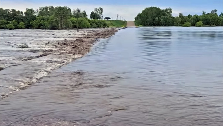
The forecast rainfall may result in localized overland flooding, particularly in low-lying areas, areas with poor drainage and areas that have already received significant rainfall from recent precipitation systems. The rainfall may also contribute to increased runoff, rising flows and elevated water levels on some rivers, streams and drainage systems.
The Hydrologic Forecast Centre has issued an overland flood watch for portions of western and northwestern Manitoba, including the Parkland Region, where forecast rainfall may result in localized flooding.
Overland flooding occurs when high-intensity rainfall over a short period generates surface runoff that exceeds the capacity of ditches, drains and natural waterways, causing water to flow across the land.
The Assiniboine River from Shellmouth Dam to Brandon continues to remain under Flood warning.
High water advisories remain in effect for:
- Lake of the Prairies (Shellmouth Reservoir);
- Swan Lake;
- Red Deer Lake; and
- Red Deer River near its mouth at Provincial Trunk Highway 10.
The Manitoba Emergency Management Organization continues to work with local authorities, First Nations and emergency management partners to provide guidance and support for response and recovery activities. This includes reviewing existing emergency plans, sharing information and preparing resources used in flood response.
The Hydrologic Forecast Centre will continue to monitor weather forecasts, river conditions, and precipitation trends and will provide updated flood information as conditions warrant. The most recent flooding information is available at manitoba.ca and additional information is available at mbready.manitoba.ca.
For information on road closures, visit manitoba511.ca.