The Manitoba government has declared a second provincial state of emergency in response to a wildfire season that is now the worst on record in the last 30 years, with more than one million hectares (ha) of area burned in the province.
Mandatory evacuation orders are in effect for the communities of Snow Lake and Garden Hill First Nation effective noon today. These evacuations will affect approximately 4,588 residents.
Evacuees requiring assistance are reminded to attend the primary evacuation reception centre in Winnipeg at the Leila Soccer Complex at 770 Leila Ave.
Manitoba Parks advises Wekusko Falls Provincial Park is closed due to wildfires. A mandatory evacuation order is in effect and all park users must vacate the area. The campground will be closed for nightly and seasonal camping until July 24. This closure may be extended, depending on how the situation develops. The Parks Reservation Service will contact affected campers directly. For updates on park closures visit manitobaparks.com.
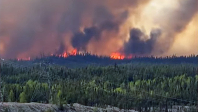
To illustrate the severity of this year’s wildfire season, Manitoba Wildfire Service advises 1,021,544 ha of area have burned in the province as of July 8. The 20-year average for this same timeframe is 94,022 ha, making the area burned in 2025 ten times higher than the average. This marks the worst wildfire season in Manitoba’s 30-year history of daily electronic records. The second worst year was 2013 at 720,560 ha burned.
Manitoba Wildfire Service reminds Manitobans to be responsible and to keep fire prevention in mind as human activity continues to contribute to the province’s wildfires.
For the safety of both evacuees and front-line and fire-fighting personnel, the province is reminding Manitobans not to enter areas under a mandatory evacuation until communities declare the situation is safe.
Travel permits are required within active fire boundaries. To view active fire boundary maps, visit: gov.mb.ca. To apply for a travel permit, contact a Natural Resources and Indigenous Futures district office and visit: gov.mb.ca to find a location.
Fires of note
The Manitoba Wildfire Service continues to respond to 105 active wildfires across the province, a total of 261 wildfires to date, well above the average for this date of 197 total fires.
Fires of note include:
East region:
- Fire EA061 remains out of control at approximately 234,390 ha. A closure and mandatory evacuation order continues for parts of Nopiming Provincial Park and the entire areas of Wallace Lake and South Atikaki provincial parks. PR 314 remains closed through Nopiming Provincial Park, as well as PR 304 east of Bissett. The southern portion of Atikaki Provincial Park is also closed, including the Bloodvein and Gammon river corridors and Aikens Lake.
West region:
- Fire WE017, located near Sherridon and the city of Flin Flon, is approximately 370,780 ha and is out of control. For the safety of personnel, boaters are asked to avoid waterways being utilized by Manitoba Wildfire Service tankers and aircraft.
- Fire WE025, located near Mathias Colomb Cree Nation (Pukatawagan), is approximately 59,220 ha and is being monitored. The fire is contained around the community but a mandatory evacuation order continues.
- Fire WE028, located 10 kilometres (km) from Bakers Narrows Provincial Park, is approximately 7,200 ha and is out of control.
- Fire WE052, located 20 km from Snow Lake, is approximately 3,000 ha and is out of control. A mandatory evacuation order was issued for the town of Snow Lake effective noon today.
- Fire WE053, located 16 km from Snow Lake, is approximately 4,370 ha and is out of control.
- Fire WE059, located 12 km from Snow Lake, is approximately four ha and is under control.
North region:
- Fire NO002, located near the town of Lynn Lake, is approximately 80,120 ha and is out of control.
- Fire NO042, located 14 km southwest from the town of Lynn Lake, is approximately 9,525 ha and is out of control. A mandatory evacuation order is in place for the town of Lynn Lake and Marcel Columb First Nation.
- Fire NO005 (combined with Fire NO055), located near Pimicikamak Cree Nation (Cross Lake), the Incorporated Community of Cross Lake, Jenpeg Generating Station and Whiskey Jack Landing, is approximately 84,375 ha and is out of control.
- Fire NO010, located near Tataskweyak Cree Nation (Split Lake), is approximately 22,275 ha and is out of control. A mandatory evacuation order remains in place for Tataskweyak Cree Nation (Split Lake).
- Fire NO026, located 14 km from the town of Leaf Rapids, is approximately 6,820 ha and is out of control. A mandatory evacuation order is in place for the town of Leaf Rapids.
- Fire NO047, located 26 km from the town of Leaf Rapids, is approximately 7,015 ha and is out of control. A mandatory evacuation remains in place for the town of Leaf Rapids. Wildfire smoke may impact PR 391.
- Fire NO061, located 14 km from the city of Thompson, is approximately 12,500 ha and is out of control.
- Fire NO076, located seven km from Wabowden, is approximately 44 ha and is out of control.
- Fire NO079 (combined with Fire NO082), located near Garden Hill First Nation (Kistiganwacheeng), is approximately 2,500 ha and is out of control. A mandatory evacuation order is in effect for Garden Hill First Nation (Kistiganwacheeng) effective July 10.
To report a wildfire, call 911 or the TIP line toll-free at 1-800-782-0076.