The Manitoba government has launched a new land use and development web application that will help communities develop their vision for the future.
“Our government is committed to reducing red tape and streamlining development processes for local municipalities and planning districts,” said Municipal Relations Minister Jeff Wharton. “Land use planning is an integral part of building healthy, thriving and sustainable communities. This new web tool will enable users to perform land use analyses that will help them to understand and visualize their community’s development potential and build a stronger, more prosperous future.”
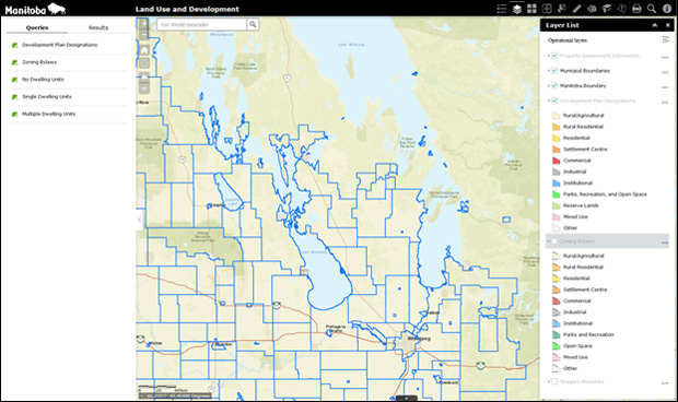
The Land Use and Development Web Application is a GIS interface. It has development plan and zoning information for all lands in Manitoba, outside of the city of Winnipeg, and it features:
- information representing land use designations and zones contained in the development plans and zoning bylaws adopted by municipalities or planning districts, and
- assessment parcel information and various base maps from Manitoba Assessment Online.
“The Land Use and Development Web App has proven to be a valuable tool for day-to-day administration,” said Ashley Pielak, administrative clerk, RM of Kelsey. “The application has greatly improved the amount and quality of municipal data and information readily available for us to assist in analysis and decision-making in regards to our municipal issues.”
Wharton noted the new web application will help communities decide the best places to develop homes, parks, agriculture and industry, and also determine where land should be left in its natural state. This will help communities manage change, and balance the demand for development with the need to protect and preserve valuable resources and the environment, he noted.
For more information, visit gov.mb.ca.