Manitoba Transportation and Infrastructure’s Hydrologic Forecast Centre reports the risk of spring flooding is low to moderate for most Manitoba rivers heading into the spring runoff period.
Spring flood risk remains largely dependent on weather conditions from now through the melt period, including additional snowfall and spring rainfall, as well as the snowmelt’s timing and rate.
Most Manitoba lakes are expected to remain within desired operating ranges after spring runoff and the risk of flooding along Manitoba lakes is low.
A moderate risk of flooding is in effect for the Red, Pembina, Assiniboine, Souris and Qu’Appelle rivers, the Interlake region including the Icelandic and Fisher rivers, and portions of the Saskatchewan River in northern Manitoba. A low flood risk is in effect for Red and Assiniboine river tributaries including the Rat and Roseau rivers. Eastern Manitoba, including the Winnipeg River basin and Whiteshell lakes area, and most Manitoba lakes have low risk of spring flooding.
Current basin conditions indicate generally low to moderate spring runoff potential. Soil moisture at freeze-up was near normal to below normal across most of Manitoba, winter precipitation has ranged from near normal to below normal in many regions and soil frost depths are generally shallower than normal, allowing greater infiltration of meltwater. Snow accumulations are generally within the normal range, except for parts of southern Manitoba where snow accumulation remains below typical values for this time of year.
Lake levels across the province are within operating ranges. Lake Winnipeg and Lake Manitoba are well-below normal for this time of year, and inflows into most major lakes are expected to be below seasonal normals, reflecting generally drier-than-normal conditions across contributing river basins.
The Red River Floodway is not expected to be operated under normal or favourable weather conditions but may be operated under unfavourable conditions to reduce water levels within the city of Winnipeg. The Portage Diversion may be operated under unfavourable weather conditions or to mitigate ice-jamming on the lower Assiniboine River. The Shellmouth Reservoir is being operated in consultation with the Shellmouth Liaison Committee to reduce downstream flood risk while maintaining water supply and recreation objectives.
Outflow from the Shellmouth Dam is expected to increase today to 1,000 cubic feet per second (cfs) from the current 768 cfs. A further increase to 1,300 cfs will happen tomorrow as part of normal winter operations. This increase is expected to cause up to a two-foot rise in water levels along the Assiniboine River from Shellmouth to Brandon. The rise will diminish as the river approaches Winnipeg.
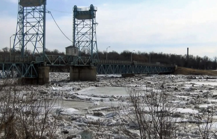
Ice-cutting and breaking activities are underway along the Red River to reduce the risk of ice-jam flooding. There is also risk of flooding on other rivers that are historically affected by ice jams including the Saskatchewan, Carrot, Swan, Icelandic and Fisher rivers.
Ice conditions and spring weather will play a key role in determining breakup timing and localized flood potential.
Spring flood risk will continue to depend on weather conditions through the melt period. As temperatures warm and ice strength deteriorates, Manitobans are reminded to stay off waterways, rivers and retention ponds.
The Manitoba Emergency Management Organization continues to work with local authorities, First Nations and emergency management partners to prepare for potential spring flooding. This includes reviewing emergency plans, sharing information, and preparing resources for flood response, as well as co-ordination with Indigenous Services Canada and Manitoba Municipal and Northern Relations for First Nations and northern communities.
An updated flood outlook is expected to be released in late March.